

No play report this week, as I wasn’t able to convene my usual Sunday session. We should be back on track next weekend however.
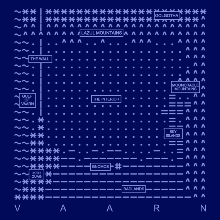
In the meantime I wanted to share the map of Vaarn that I’ve been working on. I’m sometimes reluctant to create maps of fictional spaces; for some reason I feel that they constrain my imagination and sense of possibility rather than enhancing it. I know that when a lot of people want to build a fantastical world, the map is the first thing they draw, but I’ve never felt that way inclined. However, I also felt that Vaarn needed some kind of rough geography, if only so I knew where my players might end up if they decided to walk north for two months.
I’m pretty happy with what I’ve got so far. I didn’t think the traditional Tolkienesque pen and ink aesthetic would really work for my far-future science fantasy world, so I’ve gone with an ASCII map that’s meant to evoke retro-futurism, 70s sci-fi, and old school RPGs.

I’m going to write up more about each individual region in their own posts, but for now, here’s the notes I’m working from to make each region distinct:
Lazul Mountains (North): The northern mountain range of Vaarn. Tall, new, blue peaks. Lattices of hard light in the sky overhead – ‘the cobwebs’. Mountain-dwelling Cacklemaw, rock lizards, goat-herding Faa, deep silent cave systems. Too far north and you’re in Golgotha.
The Interior (Central): Trackless blue ergs. The ‘dune sea’ of central Vaarn. Waterless, difficult to navigate. Sandworms, Faa nomad tribes, a few oases. The ‘Stone Wedding’ in the middle of the desert.
Badlands (South): Parched blue reg. Stony, hard, cactuses and martyr tree groves. The most densely populated part of Vaarn. Hegemony patrols, farming communities, arcology domes, Autarchy tombs. Gnomos is here.
Gnomos (South): The trading city, the great southern market. Ruled by the Hegemony Governor Larke xan Lonrot, and Ancamulla the Water Baron, in uneasy alliance. Big chrome gnomon in the centre, crumbling blue-stone walls, crowded blue streets and shaded souks. Wine sinks, opium dens, gladiator pits, chariot racing, theatres.
Sky Islands (East): Pink-banded mesas. Raised plateaus. Floating sky-seeking stones and structures. Outlaw and anarchist communities living above the ground. Interesting rock formations. Valley of Faces. This is where sky-seeking stone is mined.
Mooncradle Mountains (Far East): Eastern expanse of Vaarn. Banded blue and pink rocks. The Almost Moon of Ardar-Uz. Mining for various minerals, sky-seeking stones, arcane tech and vaults beneath the mountains. Gold Rush vibe. More water and more settled than the Lazul Mountains. Hegemony presence in fortified mines and refineries.
Gulf of Vaarn (Far West): The western coast of Vaarn, sheltered by the Great Wall. Flooded complexes, gleaming chrome spires scoured by salt water. Sea monsters. Scavenger communities, squid-men, the House of Tides.
The Wall / God’s Backbone (North-West): Six hundred foot, broken white wall. Has people living inside it; bizarre vertical theocracies and intricate blood feuds. Has its own weather system. Was backbone of Titans. Leaking toxins into the Ikor Quag. Gecko-men, Harpies, predatory apes.
Ikor Quag (South-West): Huge garbage waste, slick with the poisonous blood of the Titans. The detritus of millennia. Rusting hulks of war machines and spacecraft. Yurlings, hivey-men, carnivorous frogs, poisoned water and acid rain. Orbital debris falls here.
Golgotha (Far North): The grave of the Titans. Poisoned, irradiated, ontological collapse. Time paradoxes are strongest here. Self replicating nano-spires. Lightning without thunder. The machine gods are trying to reboot but cannot.

The Wall sounds super interesting and I want to learn more about it. Is it quite literally a backbone? Do the harpies and predatory apes live on the outside of the wall, or scattered inside it as well?
I’m kind of imagining it as an entirely separate world with it’s own ecosystem.
LikeLike
My idea of the Wall is it’s a superstructure that divides the desert from the ocean. Not sure how tall it is but it’s very large, visible from a long distance and is one of the ways people navigate when they’re lost in the Interior.
I think it’s kind of a wall but kind of spine-like as well? Haven’t decided on that. I know it’s bone white. It was originally part of the cooling system for the Titan AIs buried beneath Golgotha, but it was severed by some kind of orbital energy weapon during the Titanomachy and has been leaking toxic ichors for the past few millennia at the break.
So it’s non-functional but very much still standing. I imagine it having a separate ecosystem and culture to the rest of Vaarn; because it draws salt water from the ocean and purifies it, there’s human settlements inside the Wall and on top of it. There’s also greenery, and climbing creatures like the apes, geckos, giant snakes etc. I see there being life on the outside of the Wall and also inside it. It’s pretty heavily inspired by the superstructures in the game Rain World: https://www.youtube.com/watch?v=CqAdeBSunrI
LikeLike
Im so sorry to be commenting on a very old post but Im new to Vaarn and absolutely in love ith the setting. Im a 3D artist and currently working on an image set in Vaarn.
My question: How far north of The Hegemony is the Interior? The description in Zine one makes me think the actual Hegemony exists at the southern pole so that’s why Im asking.
Thank you so much for creating this weird and wonderful setting using the Dune-verse (one of my favorite settings, and Moebius (one of my favorite artists and writers.)
I looked forward to future publications.
LikeLike
Hey thanks for the comment, don’t worry at all about commenting on an old post. This is actually one of the posts that gets the most views because it fills in some geographic details that aren’t present in the published zines at all.
So my slightly annoying answer is that I don’t 100% know how far to the south the actual Hegemony is. I deliberately keep the geography of the world a bit vague so that people don’t feel too constrained by details. However, my own conception is that the heartlands of the New Hegemony are a long way from Vaarn’s Interior, like months of travel on foot or a few days in an ornithopter. So yes, more like the south pole region. It is all deliberately left vague though, so I encourage you to just go with what feels right to you personally.
I’d certainly like to see your 3D image when it’s done!
LikeLike
[…] It’s also really beautiful, using a limited palette and ASCII-style sprites. There’s even a world map, based on the map in this old post: […]
LikeLike
[…] issues of the zine, forming a loose geographic trilogy. The broad outlines of Vaarn haven’t deviated from the post I made about the continent’s geography, a few years ago now, although the specifics have shifted. Here’s where we’ll be […]
LikeLike